SIMRAD NSS12 evo³S / touch + buttons
SVB item number: 81788
Manufacturer no.: 000-15406-002


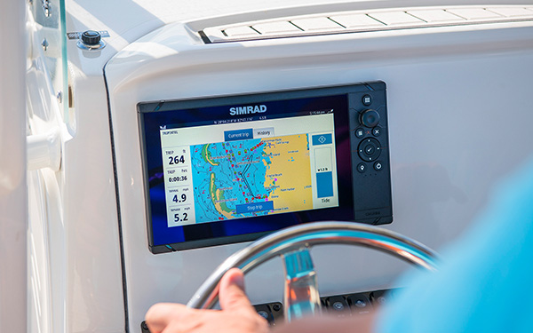
The new NSS12 evo3S features a high-resolution 12-inch widescreen SolarMAX™ display and a new, more powerful iMX 8 high-performance processor. Product details
Recommended retail price:
€4,562.67
only
€3,809.95
-16%
You save: €752.72
3
| in stock
Having issues?
If you are not redirected to PayPal, it could be due to your browser settings. Please check and if necessary deactivate the setting "Hide IP address" in the settings -> Safari -> Hide IP address. Please also check your browser for updates.
If you are not redirected to PayPal, it could be due to your browser settings. Please check and if necessary deactivate the setting "Hide IP address" in the settings -> Safari -> Hide IP address. Please also check your browser for updates.
Are you already using this item?
Add to my boat now.
At a glance!
Product data
- SVB item number 81788
- EAN 9420064130184
- Manufacturer no. 000-15406-002
- Description Simrad - NSS12 evo³S
- Series NSS evo3S
- Display size 12 Inch
- Resolution 1280 x 800 px
- Viewing angle 80 °
- Screen brightness 1200 Nits
- Operating voltage 12 V, 24 V
- Operating mode Touch screen, Keys
- NMEA2000 Yes
- NMEA0183 Optional
- WiFi Yes
- Bluetooth Yes
- Ethernet / Network Yes
- Radar capable Yes
- Tablet control Yes
- Sonar module Yes
- Sonar type CHIRP / Fishfinder, DownScan, SideScan, ForwardScan, Numerical depth
- Viewing angle Downwards, Sidewards, Forwards
- Compatible Navico transducers P79, P319, HDI, HST-WSBL, TotalScan, ForwardScan, Active Imaging, StructureScan HD, StructureScan 3D
- Nautical chart support Yes
- Sea Charts C-MAP DISCOVER, Navionics+, Navionics Platinum+, NV Charts
- Installation width 335 mm
- Installation height 197 mm
- With transducer No
- Sonar view Fish, Bottom structure
- IP protection class IPX7
- For Bavaria S 45


Product details
The new NSS12 evo3S features a high-resolution 12-inch widescreen SolarMAX™ display and a new, more powerful iMX 8 high-performance processor. Thanks to its processor, wide viewing angles and reliable control via multi-touch or keyboard with rotary knob, you will always have complete control even in harsh conditions.


Key Features
- High-performance six-core processor iMX 8
- 9-inch widescreen SolarMAX™ HD display
- Integrated high-performance echo sounder with 1 kW CHIRP
- Navigate precisely with the integrated 10 Hz GPS/GLONASS receiver with high gain
- NMEA 2000® connectivity for integrated machine monitoring, controlling your sound system, and much more
- Expand your network with additional Simrad modules including Simrad sonar, radar, autopilot and many more
- Connect to your smartphones, tablets and Internet hotspots quickly and easily with built-in Wi-Fi
- Reliable control: seamlessly switch between multi-touch and a full keypad with rotary control
- Make your route planning easier with TripIntel™ technology
- Flexible installation options incude either flat flush or convenient mounting bracket
- Includes a world base chart (no detailed charts)
Technical data
| Waypoints and routes | 6000 waypoints, 500 Routes with 100 max route points, 50 tracks with up to 12,000 track points. |
| Cartography included | World base chart (no detailed charts) |
| Supported charts | Insight, Navionics (Gold, NAV+ Platinum+) , C-MAP (MAX N, MAX N+) NV Digital |
| Radar | Broadband Radar, Halo Pulse Compression Radar, HD Pulse Radar (optional) |
| External storage | 2 MicroSD slots, max. 32GB each. Larger if formatted to NTFS |
| Internal storage | 16 GB |
| GPS | internal, 10 Hz, 34 channels |
| AIS | with optional AIS transponder |
| Interface | Full touch screen (multi-touch ) and full keypad control |
| Multimedia | with optional SonicHub2 and FusionLink |
| Autopilot | Full auto pilot control and commissioning |
| Digital switching | C-Zone, Naviop |
| Ethernet | 2x ethernet port |
| NMEA 2000 | 1 x NMEA 2000 Micro-C port |
| NMEA 0183 | 1x input, 1x output (with optional data cable SVB no: 17409) |
| Video | 2 x composite (RCA connectors) video inputs. Optional video / data cable required. No HDMI port |
| WiFi | Internal |
| Bluetooth | Internal |
| Dimensions (L x W x H) | 352 x 225 x 98 mm (13.8 x 8.87 x 3.82 inch) With bracket: 377 x 241 x 120 mm (14.85 x 9.47 x 4.71 inch) |
| Mounting type | Bracket (supplied) or panel mount |
| Weight: | 3.1 kg |
| Storage temperature range | -20°C to +60°C (4°F to 140°F) |
| Water rating | IPX6 and 7 |
| Operating temperature | -15°C to +55°C (5° F to 131° F) |
| Recommended fuse | 5A |
| Supply voltage | 10 - 31.2 V DC |
| Resolution | 800 x 1280 pixels |
| Display size and type | SolarMax HD® IPS 12" optically bonded TFT |
| Backlight | White |
| Viewing angle | 80° top/bottom, 80° left/right |
| Languages | English(US), English(UK), Danish, German, Spanish, Finnish, French, Greek, Icelandic, Italian, Dutch, Norwegian, Portuguese, Swedish |
Chart module:
SD/Micro-SD |
Compactflash |
C-Card MAX orange |
C-Card NT+ black |
Compatible with the following charts:
| C-MAP MAX-N | C-MAP MAX-N+ | C-MAP MAX-N+ Continental | Navionics+ | Navionics Platinum+ |
Chart features:
| Chart system | Vector maps | Grid/paper charts | Easy/Autorouting | Tides | Satellite images | High-resolution depth lines |
| C-MAP MAX-N | ||||||
| C-MAP MAX-N+ | ||||||
| C-MAP MAX-N+ Continental | ||||||
| Navionics+ | ||||||
| Navionics Platinum+ |
Features
Discover the features that make this product stand out. From technical details to special functions – we’ve summarized all the key information for you.
Display size
12 Inch
Operating mode
Touch screen
Keys
Optional
Radar capable
Yes
Tablet control
Yes
Viewing angle
Downwards
Sidewards
Forwards
Delivery contents
- Display
- Power cable, 4-pin
- Sunshade
- Edge trims
- Mounting bracket
- Bracket mounting kit
Documents
Product safety
Customers ask customers
No questions asked yet. Be the first to ask a question!
Similar items
-20%

SIMRAD
GO7 XSR / Touch / with Global Basemap
€749.70
only
€599.95
4
-12%
SIMRAD
GO7 XSR / Touch / with HDI Transducer
€833.00
only
€729.95
2
-12%
SIMRAD
GO7 XSR / Touch / with Active Imaging-Transducer
€987.70
only
€869.95
3
-17%
SIMRAD
GO9 XSE / Touch
€1,130.50
only
€939.95
7
-16%
SIMRAD
GO9 XSE / Touch / with 3IN1 Active Imaging Transducer
€1,307.81
only
€1,099.95
3
-16%
SIMRAD
GO9 XSE / Touch / with HDI DownScan Transducer
€1,188.81
only
€999.95
2
-20%
SIMRAD
GO9 XSE / Touch / with ForwardScan Transducer
€2,091.37
only
€1,669.95
4
-20%
SIMRAD
GO 9 XSE + HALO20+ Radar Bundle
€4,141.80
only
€3,299.95
Expected to be in stock within 1-2 weeks
-20%
SIMRAD
GO 9 XSE + TrueHeading AIS Transponder Bundle
€2,306.46
only
€1,849.95
6
SIMRAD
NSS4-10 Multifunction Display with 1 kW CHIRP Sonar Module
only
€3,199.95
E-mail Newsletter
Product news, offers & new guide videos. Stay up to date!
WhatsApp
New: Get news from SVB straight to your phone!