GARMIN ECHOMAP UHD2 72cv incl. GT20-TM Transducer
SVB item number: 93959
Manufacturer no.: 010-02593-01


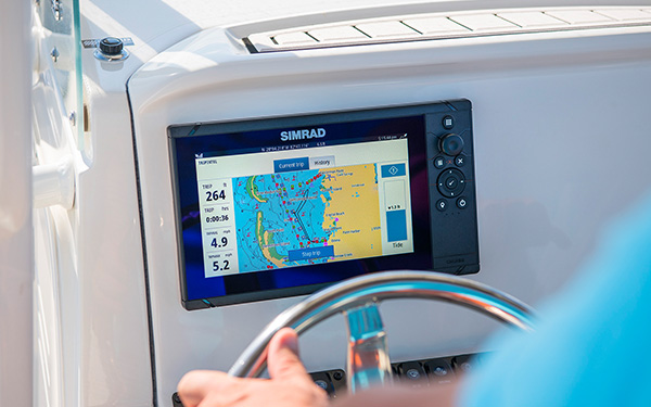
Echomap UHD2, GARMIN'S new, compact, and powerful chartplotter series, is designed for fishermen and anglers who want to look not only ahead, but also underwater - with clear, crisp sonar and in real time. Includes GT20-TM transducer. Product details
Recommended retail price:
€649.99
only
€559.95
-14%
You save: €90.04
3
| in stock
Having issues?
If you are not redirected to PayPal, it could be due to your browser settings. Please check and if necessary deactivate the setting "Hide IP address" in the settings -> Safari -> Hide IP address. Please also check your browser for updates.
If you are not redirected to PayPal, it could be due to your browser settings. Please check and if necessary deactivate the setting "Hide IP address" in the settings -> Safari -> Hide IP address. Please also check your browser for updates.
Are you already using this item?
Add to my boat now.

At a glance!
Product data
- SVB item number 93959
- EAN 0753759284657
- Manufacturer no. 010-02593-01
- Description GARMIN - Echomap UHD2 72cv incl. GT20-TM transducer
- Series Echomap UHD2
- Display size 7 Inch
- Resolution 800 x 480 px
- Operating voltage 12 V
- Operating mode Keys
- NMEA2000 No
- NMEA0183 No
- WiFi Yes
- Bluetooth No
- Ethernet / Network No
- Radar capable No
- Tablet control No
- Sonar module Yes
- Sonar type CHIRP / Fishfinder, ClearVü
- Viewing angle Downwards
- Compatible Garmin transducers P319, GT8, GT20, GT21, GT24
- Nautical chart support Yes
- Sea Charts BlueChart g3, BlueChart g3 Vision, Garmin Navionics+, Garmin Navionics Vision+
- Installation width 173 mm
- Installation height 107 mm
- With transducer Yes
- Sonar view Fish, Bottom structure
- IP protection class IPX7

Product details
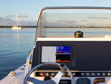
Echomap UHD2, GARMIN'S new, compact, and powerful chartplotter series, available with either a 5 or 7 inch display. With 500W of scanning power, it is designed for fishermen and anglers who want to look not only ahead, but also underwater. The new Echomap UHD2 series combines the same great stylistic elements of previous models with a clear, modern user interface, intuitive button operation and improved graphics. The bright display is easy to read even in bright sunlight. The Echomap UHD2 is everything every angler could want for a successful fishing trip, including razor sharp sonar views in real time, combined with lightning-fast chart redraw, as well as support for GARMIN Navionics+ cartography. Suitable for all inland and coastal waters.
Simple: Features a bright, 7-inch display with buttons for easy operation and control. Marking important waypoints and toggling between different chart views when fishing has never been easier.
Clear: Traditional CHIRP and CLEARVü sonar images are so clear, no fish can hide. High-contrast sonar signals in bright colours make it easy to distinguish between fish and structures.
Connected: The Echomap UHD2 chartplotter is network-compatible thanks to an integrated WiFi. Share sonar data, waypoints or routes effortlessley accross two Echomap devices. Users can also connect their device to the free ActiveCaptain app, giving access to further features including OneChart™, Smart Notifications, software updates or the GARMIN Quickdraw community.
Always on course: With GARMIN Navionics+ and GARMIN Navionics Vision+ nautical charts, you'll always stay on course and also get tons of other valuable information about the waters you're sailing in. In addition to Auto Guidance+ technology and the ability to track up to 5,000 waypoints, the pre-installed Quickdraw Contours map software is the main feature used. While the boat is in motion, the software creates fishing maps in no time and displays already surveyed areas directly on the chart plotter. Share your own maps with the ActiveCaptain community and exchange Points of Interest. But only if you want to.
Technical Data
Delivery contents:

Simple: Features a bright, 7-inch display with buttons for easy operation and control. Marking important waypoints and toggling between different chart views when fishing has never been easier.
Clear: Traditional CHIRP and CLEARVü sonar images are so clear, no fish can hide. High-contrast sonar signals in bright colours make it easy to distinguish between fish and structures.
Connected: The Echomap UHD2 chartplotter is network-compatible thanks to an integrated WiFi. Share sonar data, waypoints or routes effortlessley accross two Echomap devices. Users can also connect their device to the free ActiveCaptain app, giving access to further features including OneChart™, Smart Notifications, software updates or the GARMIN Quickdraw community.
Always on course: With GARMIN Navionics+ and GARMIN Navionics Vision+ nautical charts, you'll always stay on course and also get tons of other valuable information about the waters you're sailing in. In addition to Auto Guidance+ technology and the ability to track up to 5,000 waypoints, the pre-installed Quickdraw Contours map software is the main feature used. While the boat is in motion, the software creates fishing maps in no time and displays already surveyed areas directly on the chart plotter. Share your own maps with the ActiveCaptain community and exchange Points of Interest. But only if you want to.
Technical Data
| Display size | 7" (155 x 87 mm) |
| Display type | WVGA, TN |
| Resolution | 800 x 480 px |
| Power supply | 9-18 V DC |
| Power consumption | 1 A (typical) 1.5 A (max) |
| Power consumption | 18 W |
| Sonar power output | 500 W |
| Sonar frequencies | CHIRP: 70/83/200 kHz ClearVü: 260/455/800 kHz |
| Transducer port | 4 pins |
| GPS | Yes, integrated |
| Sea chart support | Yes |
| Charts | BlueChart g3, BlueChart g3 Vision, Garmin Navionics+, Garmin Navionics Vision+ |
| Card slot | 1x microSD |
| Waterproof | IPX7 |
| Dimensions | 232 x 143 x 67 mm |
| Weight: | 0.7 kg |
Delivery contents:
- ECHOMAP UHD2 72cv
- GT20-TM Transducer
- Power / data cable
- Tilt / swivel mount
- Flush mount gasket and hardware
- Hardware
- Documentation
Features
Discover the features that make this product stand out. From technical details to special functions – we’ve summarized all the key information for you.
Display size
7 Inch
Operating mode
Keys
No
Radar capable
No
Yes
Viewing angle
Downwards
With transducer
Documents
Product safety
Customers ask customers
No questions asked yet. Be the first to ask a question!
Comparison


Availability / Price
Item no.
93959
93958
Customer ratings
Description
GARMIN - Echomap UHD2 72cv incl. GT20-TM transducer
GARMIN - Echomap UHD2 72cv
NMEA0183
NMEA2000
Ethernet / Network
WiFi
Bluetooth
Display size
7 Inch
7 Inch
Sonar module
Operating mode
Keys
Keys
Series
Echomap UHD2
Echomap UHD2
Installation height
107 mm
107 mm
Installation width
173 mm
173 mm
Nautical chart support
Sonar type
CHIRP / Fishfinder, ClearVü
CHIRP / Fishfinder, ClearVü
With transducer
Operating voltage
12 V
12 V
Viewing angle
Downwards
Downwards
Radar capable
Sea Charts
BlueChart g3, BlueChart g3 Vision, Garmin Navionics+, Garmin Navionics Vision+
BlueChart g3, BlueChart g3 Vision, Garmin Navionics+, Garmin Navionics Vision+
Tablet control
Sonar view
Fish, Bottom structure
Fish, Bottom structure
Resolution
800 x 480 px
800 x 480 px
IP protection class
IPX7
IPX7
Compatible Garmin transducers
P319, GT8, GT20, GT21, GT24
P319, GT8, GT20, GT21, GT24
Similar items
-9%

GARMIN
GPSMAP 723 Multifunction Display
€1,049.00
only
€949.95
4
-7%
GARMIN
GPSMAP 723xsv with Sonar Module
€1,259.00
only
€1,169.95
Available on 08.06.2026
-6%
GARMIN
GPSMAP 923
€1,579.00
only
€1,479.95
4
-6%
GARMIN
GPSMAP 923xsv with Sonar Module
€1,789.00
only
€1,679.95
2
-7%
GARMIN
GPSMAP 1223
€3,048.99
only
€2,849.95
Expected to be in stock within 1-2 weeks
-5%
GARMIN
GPSMAP 1223xsv with Sonar Module
€3,259.01
only
€3,079.95
Expected to be in stock within 4-6 days
GARMIN
GPSMAP 8410
only
€2,799.95
> 4
-8%
GARMIN
GPSMAP 8410xsv
€3,149.00
only
€2,899.95
Expected to be in stock within 1-2 weeks
-7%
GARMIN
GPSMAP 8412
€4,099.00
only
€3,799.95
> 7
GARMIN
GPSMAP 8416
only
€6,199.95
Last seen products
YACHTCARE
Bonding Steel
only
€18.95
(€151.61 / kg)
MERCURY
JET Main 6 HP
from
€9.95
2 variants
-42%
SEATEC
Motor Service Kit for Volvo Penta
€70.23
from
€40.95
15 variants
STERLING
Portable Induction Hob / 230 V / 1500 W
only
€81.95
33
BAVARIA
Fuel Tank Sensor / 270 mm
only
€279.95
3
-6%
RONSTAN
Orbit Ratchet Footblock / ACW / 10 mm / ball bearing
€105.80
only
€99.95
2
-18%
WICHARD
Fiddle Block with Swivel / 12 mm / plain bearing
€55.80
only
€45.95
5
-14%
ISOTHERM
CRUISE Elegance Refrigerator / 49 liter
€1,101.94
only
€949.95
1
E-mail Newsletter
Product news, offers & new guide videos. Stay up to date!
WhatsApp
New: Get news from SVB straight to your phone!