AXIOM 9 / Touch / with Navionics+ REGULAR Chart Download


A powerful new multifunction navigation system from Raymarine. With all new LightHouse 3 operating system and blazing fast quad core performance, Axiom will transform your time on the water. A Navionics+ REGULAR Download nautical chart is included. Product details
This product is no longer available.
More alternatives:
RAYMARINE


Product details
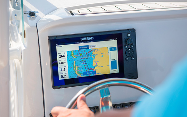
AXIOM - The powerful new multifunction navigation system from Raymarine
Thanks to the new LightHouse 3 operating system and blazing fast quad-core processors, this multifunction display boasts excellent performance. In addition, the AXIOM is expandable so its capabilities can grow as needed.

Lightning-fast performance at the touch of a finger
Clear app icons make orientation easier, a simple swipe across the multifunctional display activates the sidebar with the data display.
Using drag and drop, the data fields can be positioned anywhere on the screen in different sizes.
The homepage with the user profile and personal configuration can be saved permanently on the device. With just a few finger touches you can take control via touchscreen.
The chartplotter can also be adapted to individual requirements. Clear menus also provide quick access to the various chart modes.
Simply placing the tip of your finger on the chart is enough to position the cursor.

New LightHouse 3 operating system
The display is switched on and off via a sensor field on the display. Thanks to excellent processor performance, the operating system is blazing fast.
Easy to read and customize according to your personal preferences, navigation with the AXIOM has never been easier.

Network & Connection
For integration into an existing network or creating a new network, the AXIOM units have NMEA2000 and Ethernet interfaces.
The devices also feature a microUSB port, integrated WiFi and Bluetooth.
The devices also feature a microUSB port, integrated WiFi and Bluetooth.

The best charts
Raymarine's multifunction devices allow you to choose between charts from Navionics, C-Map and an extended Lighthouse chart selection.
The detailed grid and vector charts make coastal navigation very easy
and also contain options for 3D charts and satellite support.
A Navionics+ Small Download nautical chart is included.
The detailed grid and vector charts make coastal navigation very easy
and also contain options for 3D charts and satellite support.
A Navionics+ Small Download nautical chart is included.
Specifications
| Display size | 9" LCD |
| Resolution | 800 x 480 WVGA |
| Display type | Multi-touch |
| Brightness | 1,200 nits |
| Dimensions | 244 x 158 x 75 mm (9.64" x 6.21" x 2.96") |
| Weight: | 2.04 kg (4.5 lbs) |
| Waterproof | IPX6 / IPX7 |
| Operating temperature | -25°C to +55°C |
| Storage temperature | -30°C to +70°C |
| Voltage | 12V DC (8V to 16 VDC) |
| GNSS/GPS | Built-in GNSS receiver: GPS/GLONASS 10Hz 72 channels (optional: RS150) |
| Radar | Yes - eg Quantum, Digital, HD colour and Super-HD-colour radars |
| AIS | Yes - via NMEA2000 |
| Video | Up to 10 IP cameras |
| Ethernet | 1 x 10/100 Mbits network (RayNet) |
| NMEA0183 | Requires a NMEA2000 adapter |
| NMEA2000 | 1x NMEA2000 port (microC plug) |
| SeaTalk | No |
| USB | 1x USB micro |
| WiFi | Yes |
| Bluetooth | Bluetooth 4.0 |
| waypoints | 10,000 wpts / 200 wpts groups |
| Internal storage | 4GB |
| Included | AXIOM 9 display, trunnion bracket, 2x trunnion knobs, suncover, panel mount gasket for surface/flush mounting, 2x rear mounting brackets, 4x M5x58 threaded studs, 4x M5 thumb nuts, documentation pack, power/ NMEA 2000 cable (with 1.5m (4.92ft) power lead and 0.5m (1.64ft) NMEA 2000 connection cable) Navionics+ SMALL Download chart |
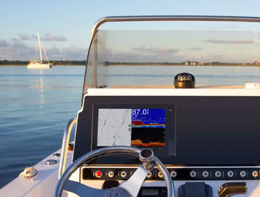
Depth / fish finder views
Depending on the connected transducer, the chartplotter can display the following depth views. The pure depth display refers to transducer data received via NMEA2000 interface. Some functions can be retrofitted via external modules.
Pure depth representation |
Fish finder / CHIRP |
Down vision |
RealVision 3D |
Charts
SD/Micro-SD |
Compactflash |
C-Card MAX orange |
C-Card NT+ black |
Compatible with the following charts:
| C-MAP 4D | C-MAP 4D Full | C-MAP 4D Continental | Navionics+ | Navionics Platinum+ |
Chart features:
| Chart system | Vector maps | Grid/paper charts | Easy/Autorouting | Tides | Satellite images | High-resolution depth lines |
| C-MAP 4D | ||||||
| C-MAP 4D Full | ||||||
| C-MAP 4D Continental | ||||||
| Navionics+ | ||||||
| Navionics Platinum+ |
Documents
Product safety

Customers ask customers
General question
João d.
| Oct 22, 2021

Does it include Navionics+ Central and West Europe 46XG? Item N 77238
Answer from SVB customer service
Julian I.
| Oct 13, 2022
Hi Joao! You can choose of any Navionics + cards. We don't just sell one territory with this offer.
General question
Jan O.
| Mar 5, 2020
Hi, if I buy RAYMARINE AXIOM 9 with Navionics+ Chart Download can I download UK & Ireland Inland (Navionics code: 5G576S2) https://www.navionics.com/fin/navionics-plus-small-uk-ireland-inland.html for free? Many thanks John
Answer from SVB customer service
Arne C.
| Mar 6, 2020
Hello Jan, Yes you can. More comfortable for you is to order at the same time 5G576S2, our Articel 776952 NAVIONICS + UK and Ireland Inland Waters / Small as a preloaded card
General question
Marc S.
| Dec 2, 2018
The description states : "Navionics+ Download Chart included in delivery contents". What chart is actually included? Is it the Navionics+ 'small' or 'large'. How can one specify the chart 'area' when ordering? Is there any difference with the Navionics+ charts ordered separately?
Answer from SVB customer service
Arne C.
| Dec 3, 2018
Hello Marc, the Navionics SMALL is inclued. The how to is described here (temporarilly only in german language) https://www.svb24.com/en/navionics-navionics-small-preformated-marine-chart-module.html. An english version you find also on manufacturer homepage. The significant difference to ordered separately cards is, that i.e. XG45 is preconfigured and not variable, the small-cards are by yourself with your own area programmable
Answer
Marc S.
| Dec 3, 2018
Hello Arne, thank you for your answer. I do not understand why Raymarine says that the 'Axiom+download' alternative is a cheap way to get the charts. If only one 'small' chart is included, then I need to download and pay for two more 'small' charts to cover Greece (my current sailing area). It is much cheaper to purchase separately the 'Axiom, naked' and the 'Navionics+ Large' that cover the whole Mediterranean + Black Sea! Do I overlook/miss something?
Customers also bought
-13%

YACHTICON
Premium Polish
€22.96
only
€19.95
(€39.90 / L)
> 100
-17%
QUICK
B3 Water Heater / stainless steel / 15-80 litre
€589.65
from
€489.95
12 variants
-18%
DECKMATE
Scrubber Handle, telescopic
€42.49
only
€34.95
30
-22%
DECKMATE
Deck Brush, soft / gray
€38.23
only
€29.95
21
-18%
DECKMATE
Cleaning Mop
€104.18
only
€84.95
7
NMEA2000
Starter Kit / Micro-C
only
€133.95
> 100
DULON MARINE
Shampoo / Wash & Wax
only
€17.95
(€35.90 / L)
9
-22%
DECKMATE
DM510 Angle Adapter
€24.41
only
€18.95
20
-11%
NAUTIC CLEAN
Nano Wax Shampoo No. 06
€17.89
only
€15.95
58
-5%
NAVIONICS
Navionics+ Mediterranean & Black Sea / 43XG / NAEU643L / Large
€250.00
only
€236.95
22
Similar items
NEW
RAYMARINE
AXIOM 2 7 Touch
only
€1,149.95
2
NEW
RAYMARINE
AXIOM 2 7 RV Touch / integrated RealVision Sonar Module
only
€1,399.95
1
NEW
RAYMARINE
AXIOM 2 9 Touch
only
€1,889.95
1
NEW
RAYMARINE
AXIOM 2 9 RV Touch / integrated RealVision sonar module
only
€2,119.95
2
NEW
RAYMARINE
AXIOM 2 12 Touch
only
€3,499.95
NEW
RAYMARINE
AXIOM 2 12 RV Touch / integrated RealVision Sonar Module
only
€3,749.95
-20%
RAYMARINE
AXIOM+ 7 / Touch
€946.05
only
€759.95
Available on 15.06.2026
-19%
RAYMARINE
AXIOM+ 7 / Touch / with Integr. RealVision 3D Sonar
€1,184.05
only
€959.95
2
-20%
RAYMARINE
AXIOM+ 7 / Touch / with Integr. RealVision 3D Sonar and RV-100 Transducer
€1,541.05
only
€1,229.95
1
-20%
RAYMARINE
AXIOM+ 9 / Touch / with Integr. RealVision 3D Sonar
€1,719.55
only
€1,369.95
Available on 15.06.2026
Last seen products
E-mail Newsletter
Product news, offers & new guide videos. Stay up to date!
WhatsApp
New: Get news from SVB straight to your phone!