Element 9 HV / buttons / with Hypervision sonar and HV-100 transducer


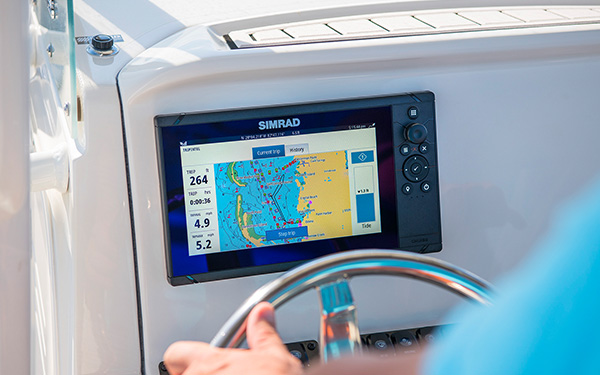
Smart 9" multifunction display with user-friendly interface and integrated GPS antenna.A touch screen was deliberately omitted from the design, as the classic button controls in connection with the Raymarine Lighthouse Sport operating system make for intuitive and precise control of the device, even at high speeds and strong seas. With built-in HyperVision sonar technology for outstanding image quality of the underwater world. HV-100 transducer included. Product details
This product is no longer available.
More alternatives:
Fishfinder/Chartplotter Combos


Accessories


Product details

Smart 9" multifunction display with user-friendly interface and integrated GPS antenna. A classic keypad and the Raymarine LightHouse Sport interface make for intuitive operation. With built-in HyperVision sonar technology for outstanding image quality of the underwater world. The fast QuadCore processor is more than adequate for mapping and continuous 3D rendering. HV-100 transducer included.

Raymarine Quantum Radar

NMEA2000 Support

With the NMEA2000 (Micro-C) interface you can clearly display AIS, tank, engine, compass and wind data. This allows you to view incoming AIS targets directly on nautical charts and keep an eye on the surrounding shipping traffic. With the help of the data bar you can monitor your current tank levels for instance.
HyperVision 1.2 MHz Sonar Technology
HyperVision sonar technology uses top frequencies of up to 1.2 megahertz and CHIRP technology. This allows for a much higher image resolution compared to other systems. The top frequency of 1.2 MHz can reach a range of up to 30 meters at a beam angle of 180°. Use it to bring DownVision, SideVision and RealVision 3D imaging to a new level and to see structures, underwater vegetation and fish in photo-like clarity.
With the standard 350 kHz CHIRP sonar, you can receive high-resolution images at a range of up to 183 meters (DownVision) and 91 meters (SideVision / RealVision 3D). In addition, the classic CHIRP sonar operates at 200 kHz down to a depth of 274 metres.
Raymarine LightHouse Sport
Intuitive and visually striking user interface. Thanks to pre-configured home screens, every user has the start screen needed for his or her needs immediately at hand.
Thanks to the ergonomically positioned buttons, navigation through the menus and placing waypoints and routes is quick and easy even without a touchscreen. Through an NMEA2000 interface, the Element-HV can display a wide range of data from external devices such as AIS receivers or tank sensors.
Your own nautical charts with RealBathy
With the new RealBathy function you can create your own nautical charts. Simply activate the function and your Element multifunction display with sonar function will create the nautical chart of your area. You can determine the overlay and display safety depths. Insert a large enough memory card into your device to do so.

Technical Specifications
| Screen size | 9" |
| Touchscreen | Non-Touch |
| Screen resolution | 800x480 |
| Brightness | 1500 Nits |
| Network and compatibility | |
| GPS | Integrated GPS / GNSS receiver: GPS / GLONASS |
| Sonar | CHIRP Sonar, DownVision (Standard and Hyper), SideVision (Standard and Hyper), Realvision 3D (Standard and Hyper) |
| Sonar connection | 15-pin HyperVision ™ connector |
| Sonar depth | CHIRP sonar = 274 m (900 feet) DownVision ™ Standard = 183m (600ft) | DownVision ™ Hyper = 30m (100ft) SideVision ™ Standard = 91 m (300 feet) | SideVision ™ Hyper = 30m (100ft) RealVision ™ 3D Standard = 91 m (300 feet) | RealVision ™ 3D Hyper = 30m (100ft) |
| Nautical charts specification | |
| Supported nautical charts | Raymarine LightHouse NC2, Navionics, C-MAP Essentials, C-MAP 4D MAX + and all charts listed on the Raymarine Chart Store. |
| Waypoints routes | 10,000 waypoints / 200 waypoints groups / 150 routes with max 250 waypoints / 16 tracks - 10,000 track points per track |
| Other specifications | |
| Interfaces | NMEA2000-Limited (engine, tank sensor & compass data input, data output: GPS for radio), Wi-Fi, Bluetooth For NMEA2000 GPS and AIS data update free of charge to the current Element Lighthouse Version 3.9. More information can be found on the Raymarine support page. |
| Dimensions | 287 x 161 x 62 mm |
| nominal voltage | 12V DC (8V - 16V DC) |
| current consumption | 20 W |
| water resistance | IPX6 and IPX7 |
| operating temperatur | -25 ° C to + 55 ° C |
| delivery | Mounting bracket with fixings, surface mounting kit with fixings, sun shade, 1.5 m power / NMEA2000 cable, documentation, HV-100 transducer with 6 m cable transom mount with mounting parts, P-clips with mounting screws, cover plate with mounting parts |
Depth / fishfinder views
Depending on the optionally connected transducers, the chartplotter can display the following depth views. The pure depth display refers to transducer data received via a NMEA0183 or NMEA2000 interface. Some functions can be retrofitted via external modules.
Pure depth display |
Fishfinder / CHIRP |
Down vision |
RealVision 3D |
Compatible with:


Charts module:
SD / Micro SD |
CompactFlash |
C-Card MAX orange |
C-Card NT + black |
Compatible with the following nautical charts:
| C-MAP 4D | C-MAP 4D Full | C-MAP 4D Continental | Navionics + | Navionics Platinum + |
Nautical charts features:
| Chart system | Vector maps | Raster / paper charts | Easy- / AutoRouting | Tide display | Satellite images | High-resolution depth lines |
| C-MAP 4D | ||||||
| C-MAP 4D Full | ||||||
| C-MAP 4D Continental | ||||||
| Navionics + | ||||||
| Navionics Platinum + |
Documents
PDF (2,01 MB)
PDF (6,18 MB)
PDF (2,28 MB)
PDF (166,10 KB)
PDF (1,10 MB)
PDF (2,38 MB)
PDF (1,91 MB)
PDF (6,22 MB)
PDF (1,11 MB)
PDF (1,91 MB)
PDF (1,11 MB)
PDF (1,10 MB)
PDF (1,89 MB)
PDF (1,91 MB)
PDF (1,12 MB)
PDF (6,23 MB)
PDF (1,90 MB)
PDF (1,11 MB)
PDF (6,21 MB)
PDF (1,11 MB)
PDF (1,90 MB)
PDF (6,21 MB)
PDF (1,89 MB)
PDF (1,10 MB)
Product safety


Images for this rating
by
Andre Z.
 8/2/2023
Verified purchase
8/2/2023
Verified purchase
by
Andre Z.
8/2/2023
Verified purchase
Customers ask customers
No questions asked yet. Be the first to ask a question!
More "Customers ask customers" available in the following languages

Customers also bought

INTERNATIONAL
ORIGINAL One-Component Clear Varnish
from
€30.95
(€41.27 / L)
2 variants
GLEISTEIN
Leaded Anchor Line
from
€169.95
4 variants
BAVARIA
PVC Skirting Board
from
€259.95
2 variants
AQUA SIGNAL
CARY Handheld LED Spotlight
only
€119.95
1
RAYMARINE
Extension Cable for Hypervision HV-100 / HV-300 Transducer / 4m
only
€104.95
1
TESSILMARE
BINO 65/90 Stainless Steel Mounting Strip / 2 m
only
€43.95
67
Similar items
-24%
RAYMARINE
Element 7S / buttons / CHIRP Sonar Module
€529.55
only
€399.95
11
-6%
LOWRANCE
Eagle 5 with SplitShot™ HD Transducer
€391.51
only
€369.95
1
-8%
LOWRANCE
Eagle 7 with SplitShot™ HD Transducer
€546.21
only
€499.95
Expected to be in stock within 4-6 days
-8%
LOWRANCE
Eagle 7 with TripleShot™ HD Transducer
€653.31
only
€599.95
2
-6%
LOWRANCE
Eagle 9 with TripleShot™ HD Transducer
€831.81
only
€779.95
1
-16%
LOWRANCE
Eagle 9 with 50/200 kHz HDI Transducer
€772.31
only
€649.95
3
Last seen products
E-mail Newsletter
Product news, offers & new guide videos. Stay up to date!
WhatsApp
New: Get news from SVB straight to your phone!