GPSMAP 922 with GMR18 HD+ Radar


This set consists of the GARMIN GPSMAP 922 and GMR18 HD+ radome radar antenna. Product details
This product is no longer available. But a successive product is available:
Available variants


Product details
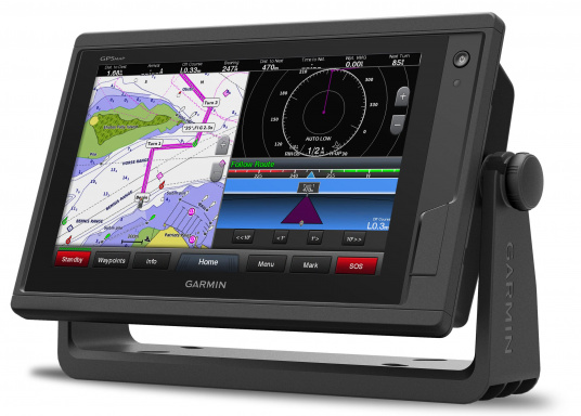
GPSMAP 922
9" Multifunction Display

Experience an advanced navigation solution with the compact GPSMAP 922 chartplotter with 9-inch touchscreen. Includes wireless connectivity for Garmin mobile apps, as well as ANT® connectivity for wireless connection of compatible Garmin sensors. It also has support for NMEA 2000 and NMEA0183, and the Garmin marine network to connect radar antennas and multiple GPSMAP multifunction displays.
Choose your personal BlueChart g3 or BlueChart g3 Vision marine charts from a variety of sailing areas. The BlueChart g3 Vision nautical charts offer additional 3D views and aerial photography.
Chart support
The integrated 10 Hz GPS receiver in combination with the multi-touch display with the latest pinch-to-zoom technology make the 9" display of the Garmin GPSMAP 922 a full-fledged chart plotter.
Choose from Garmin BlueChart g3 or BlueChart g3 Vision charts. The GPSMAP 922 has two micro-SD chart slots.
Enjoy the latest chart features such as Auto Guidance and other premium navigation functions.
| BlueChart function | BlueChart g3 | BlueChart g3 vision |
| Integrated data from Garmin and Navionics | ||
| Auto-guidance technology | ||
| Depth lines of up to 0.3m | ||
| Depth range shading | ||
| Shallow water shading | ||
| Raster charts | ||
| Navigational aids, depth information, depth lines, tides and currents, detailed ports and marinas | ||
| High resolution shading | ||
| High resolution satellite images | ||
| 3D views (MarinerEye and FishEye) | ||
| Aerial views |


Integrated WiFi & ANT®
Thanks to the integrated ANT® and WiFi interface, you can, for example, wirelessly connect the GRID20 remote control and a variety of other sensors to your GPSMAP 922.

The free ActiveCaptain™ Universal app (available for iOS and Android) lets you connect your GPSMAP 922 to your mobile device. With the ActiveCaptain™ app, you can access your maps and plan routes from the comfort of your home. The app automatically synchronises with your GPSMAP 922 when you connect.
With the integrated HELM function, you can mirror your GPSMAP 922's current display to your mobile device and even operate the plotter. -So you can easily plan your next trip from below deck using your tablet, leaving the plotter at the helm.
When new software updates are available for the chartplotter, you will receive a notification on your smartphone or tablet and can download the update at home and synchronise it with your chartplotter on board.
The ActiveCaptain™ app gives you access to the active ActiveCaptain community, which informs you about boat POIs (Points of Interest), local attractions and marinas.
NMEA2000 support

Full NMEA2000 connectivity
The Garmin GPSMAP 922 is equipped with an NMEA2000 interface (Micro-C connector). This allows easy networking and fast exchange of data between different instruments and sensors.
For example, connect the GRID20 remote control to NMEA2000 instead of a wireless connection and expand your NMEA2000 network step by step with additional components such as AIS transceivers, wind sensors, instruments, depth sensors and many more.
Thanks to the NMEA2000 standard, the GPSMAP 922 is also compatible with NMEA2000-capable sensors from other manufacturers. Depending on the NMEA2000 network, you can display data such as the following:
- Wind data (wind direction, speed)
- Depth & temperature data
- Speed through water and speed over ground (SOG)
- Environmental parameters
- Position & navigation data
- Compass / heading data
- AIS data
- Dynamic engine parameters
Garmin radar / marine network compatible
Doppler radar support
Enjoy the latest radar technology and take advantage of the Doppler effect. In combination with a Garmin Fantom Doppler radar antenna you can detect fast moving targets and avoid possible collisions thanks to the different colouring of the radar echoes. With a range of 6m to 48 nautical miles, the Fantom radar antennas always provide clear echoes both at close and long range.
Innovative software on the terminals enables moving targets to be displayed in different colours to show whether they are approaching or moving away. For example, approaching targets are marked red as a warning and distant targets are displayed in green.
The colour-coded displays make it easy to distinguish moving traffic from stationary targets. Stationary objects such as land, bridges, buoys or barrels, as well as ships at anchor or in roadsteads, are displayed as normal echoes.
The Doppler radar helps to quickly detect dangerous obstructions, especially on trips with poor visibility. The interpretation of the coloured display is easy to understand even for inexperienced skippers and can be an essential safety aspect on board in addition to AIS systems.
The GPSMAP 922 is also compatible with Garmin GMR xHD radar antennas, which do not use the Doppler effect but still offer high resolution and dynamic filters. Another handy feature is the "area without radar transmission" function. This means that no radar beams are transmitted in user-defined areas. This allows a more flexible installation anywhere on the boat.
You can find more useful information about radar antennas and their differences in our radar antenna guide .


Easy connection
Use the Garmin marine network interface to connect, for example, radars or external fishfinder boxes to the GPSMAP 922. You can also use the Garmin Marine Network Interface to connect multiple GPSMAP 922 units to exchange data. If you want to connect more than one device such as a radar antenna and a second GPSMAP922, a GMS10 Marine Network Switch is required.
With the robust Garmin GMS10 Marine Network Switch, multiple chartplotters and sensor devices can be connected together via the Garmin marine network. Take advantage of a reliable and fast data connection between your Garmin marine network enabled devices.
Connecting devices to the Garmin GMS10 is done via plug and play, meaning all devices and displays are connected via a Garmin marine network cable. The device identification in the network is fully automatic.
The rugged GMS10 was developed especially for the harsh offshore environment. All connections are kept absolutely waterproof and sealed covers protect unused connections from harmful moisture.
More functions
Sail Assist Features
To help you gain a wind-maximising competitive edge, your chartplotter features a pre-race guidance page that shows your virtual starting line along with data fields showing laylines, time to burn before the start and a race timer that can be synchronized across all your networked Garmin GPS products. In addition, other supported sailing features include an enhanced wind rose, heading and course-over-ground lines, set and drift, true and apparent wind data and more.
.
Position update with 10Hz
Thanks to the integrated GPS / GLONASS receiver with 10 Hz, the position and the heading are updated 10 times per second. This makes the position movements much smoother. Thanks to the generous memory of up to 5,000 points, you can create a large database of your favourite routes.
GPX waypoint transfer
If you have waypoints, tracks or frequently used routes stored on another manufacturer’s GPS product — or on a Garmin handheld device — it’s easy to transfer those items to your new Garmin chartplotter via industry-standard GPX software formatting.
Technical data
| Dimensions | 256 x 162 x 52 mm |
| Display size, W x H | 196 x 114 (9 ") |
| Display resolution, W x H | 1024 x 600 pixels |
| Display type | Multi-touch WVGA touch screen |
| Weight | 0.9 kg |
| Antenna | Internally or externally via NMEA 2000 |
| NMEA 2000 compatible | Yes |
| NMEA 0183 compatible | Yes |
| SiriusXM™ Weather & Radio compatible | Yes |
| Mounting options | Installation with bracket or flush |
| Garmin Marine Network ports | 1 |
| Preloaded maps | No |
| Accepted data cards | 2 microSD ™ memory cards |
| Waypoints | 5000 |
| Routes | 100 |
| Track log | 50,000 points, 50 saved tracks |
| Garmin radar compatible | Yes |
| Garmin sonar compatible | Yes (with external black box, available separately) |
| Garmin SmartMode compatible (custom monitor presets) | Yes |
| Supports AIS (tracking the position of the target boat) | Yes |
| Supports DSC (display of position data from DSC-capable FM radio) | Yes |
| Tide tables with optional BlueChart card | Yes |
| Garmin Meteor Audio System compatible | Yes |
| Supports Fusion Lync compatible marine radios | Yes |
| GSD Black Box sonar support | Yes |
| GCV black box sonar support | Yes |
| BlueChart Mobile (planned) | Yes |
| Garmin helm compatible | Yes |
| GRID (Garmin Remote Input Device) compatible | Yes |
| Wireless remote compatible | Yes |
| CHIRP sonar technology | Yes with an external black box |
| ClearVü | Yes (with external black box) |
| SideVü | Yes (with external black box) |
| NMEA 0183 input ports | 1 (differential) |
| NMEA 0183 output ports | 1 (differential) |
| video input ports | 1 BNC |
| video output ports | No |
| Wireless connectivity | Yes |
| Additional | User interface: Multi-touch touchscreen, Automatic backlight dimming: Yes, Compatible with VIRB®, Compatible with wearables via ANT, Compatible with gWind Wireless 2 |
| Delivery contents | GPSMAP 922 chart plotter, power cord, bail mount kit, installation kit for flush mounting with seal, protective cover, trim piece snap covers, documentation |
GARMIN - GMR 18 HD+ Radar Antenna
The compact size of the Garmin GMR18 HD+ radome radar antenna makes it ideal for boats where radar antenna space is limited. Its 4 kW transmit power ensures clear signals are transmitted and received over all ranges, making it easier to interpret radar echoes, increasing situational awareness, especially in poor visibility. Received radar echoes can be laid over a Garmin chartplotter map as a so-called radar overlay. For a smooth and jitter-free radar overlay the use of an optional heading sensor such as the 9-Axis Heading Sensor (item: 81775) or an autopilot system with heading sensor is necessary. Furthermore, the Garmin GMR18 HD+ in combination with a compatible heading sensor and a multifunction display supports further functions such as MARPA (Mini-Automated-Radar-Plotting-Aid) target tracking.
Thanks to the dynamic automatic amplification of echoes, the radar image adapts to the current surroundings, thus ensuring optimum performance in all conditions. In addition, the dynamic sea state filter adjusts sea clutter depending on the current sea conditions. A clear display on Garmin chartplotters is achieved by the GMR18 HD+'s 8-bit True Color resolution. Maximum range is 36 nautical miles, minimum range is a good 20 meters and rotation speed is 24 rpm.
Features
- 18-inch radome radar with 4 kW output in aerodynamic design
- 4 kW transmission power enables the GMR18 HD+ to deliver clear signals over all ranges
- Dynamic Auto Gain automatically adjusts to your surroundings to ensure optimal performance in all conditions
- Dynamic sea state filter automatically adapts to changing sea conditions
- Displays the radar image superimposed on the chartplotter chart page (autopilot or heading sensor recommended for best results)
Technical specifications
| Type | radome |
| Voltage | 11 - 35 V |
| Typical power consumption | 30 W. |
| Maximum power consumption | 48 W. |
| Transmission power | 4 kW |
| Rotation speed | 24 rpm |
| Beam width | horizontal: 5.2 ° vertical: 25 ° |
| Minimal area | 20 m |
| Maximum area | 36 nm |
| Radar overlay support | Yes |
| Tracking via MARPA | Optional (heading sensor required) |
| High definition | Yes |
| Protection zone alarm | Yes |
| Water resistance | IPX7 |
| Dimensions (Øxheight) | 508 x 248 mm |
| Weight | 7.7 kg |
Included
- GMR 18 HD + radom antenna
- Mounting kit
- Power cable (15 m)
- Network cable (15 m)
- Installation instructions
- Mounting template
Documents
PDF (1,03 MB)
PDF (6,74 MB)
PDF (5,39 MB)
PDF (472,36 KB)
PDF (613,04 KB)
PDF (302,18 KB)
PDF (6,81 MB)
PDF (5,42 MB)
PDF (703,40 KB)
PDF (480,96 KB)
PDF (1,03 MB)
PDF (6,81 MB)
PDF (5,42 MB)
PDF (488,54 KB)
PDF (5,41 MB)
PDF (491,19 KB)
PDF (6,81 MB)
PDF (1,04 MB)
PDF (5,40 MB)
PDF (6,79 MB)
PDF (1,03 MB)
PDF (468,67 KB)
Product safety


Customers ask customers
Technical question
jan B.
| Oct 20, 2020

what is the difference between the Garmin GPSMAP 922 and the GPSMAP 922 plus. they have the same sensors? map? NMEA2000 network (backbone cable with drop cables) . both can use the came rader . what is the advantage of the 922 plus ? (600€ difference)
Answer
Cabral I.
| Oct 20, 2020
922 is EOL (end of life) and 922 Plus is the evolution. If you want the list of differences between specs, it's easyer if you seek this information on Garmin site. I had the same question and I decided to buy the 922.
Answer
jan B.
| Oct 20, 2020
thank you, i looked at their site the 922 can have the garmin radar and the sensors ( depth/speed/wind ) , the same as the 922 plus. is there any advantage for the 922 plus? ( i did not find it , even screen looks the same)
Hi, the main difference is a faster processor and OneHelm functionality. The faster processor is interesting when building bigger networks with multiple chartplotters and other devices for example. For OneHelm you will find information on the Garmin website.
Customers also bought
-14%

YACHTICON
Highly Purified Kerosene
€34.95
only
€29.95
(€5.99 / L)
60
HEMPEL
One-Component UNDERWATER PRIMER
from
€24.95
(€33.27 / L)
2 variants
BLUE SEA
Fuse Box C6
only
€61.95
6
-16%
EPIFANES
One-Component Hardwood Oil Varnish
€52.12
only
€43.95
BLUE SEA
Fuse Box C12
only
€76.95
9
Splice online

GLEISTEIN
GeoTWIST POLYESTER - Three-Strand Mooring Line / navy blue
from
€1.70
6 variants
Similar items
-9%
GARMIN
GPSMAP 723 Multifunction Display
€1,049.00
only
€949.95
4
-7%
GARMIN
GPSMAP 723xsv with Sonar Module
€1,259.00
only
€1,169.95
Available on 08.06.2026
-6%
GARMIN
GPSMAP 923
€1,579.00
only
€1,479.95
4
-6%
GARMIN
GPSMAP 923xsv with Sonar Module
€1,789.00
only
€1,679.95
2
-7%
GARMIN
GPSMAP 1223
€3,048.99
only
€2,849.95
Expected to be in stock within 1-2 weeks
-5%
GARMIN
GPSMAP 1223xsv with Sonar Module
€3,259.01
only
€3,079.95
Expected to be in stock within 4-6 days
GARMIN
GPSMAP 8410
only
€2,799.95
> 4
-8%
GARMIN
GPSMAP 8410xsv
€3,149.00
only
€2,899.95
Expected to be in stock within 1-2 weeks
-7%
GARMIN
GPSMAP 8412
€4,099.00
only
€3,799.95
> 7
GARMIN
GPSMAP 8416
only
€6,199.95
Last seen products
JOCKEL
Powder Fire Extinguisher / 1 kg / fire classes ABC / manual / fluorine-free
only
€60.95
10
-15%
HONDA
BF 10 LRU Outboard Motor / Long Shaft / Electric Start / Remote Control
€4,459.00
only
€3,769.95
5
-8%
FORTRESS
Plate Anchor / Aluminium
€217.90
from
€199.95
3 variants
NASA MARINE
CRUISER Echo-Sounder (Instrument / Sensor)
only
€164.95
6
HEMPEL
SILIC ONE Biocide-Free Antifouling
from
€57.95
(€77.27 / L)
6 variants
ISOTHERM
Compact Classic GE 150 Cooling System / with flat evaporator
only
€589.95
4
FEIN
Cutting Blade 4 mm
only
€51.95
19
E-mail Newsletter
Product news, offers & new guide videos. Stay up to date!
WhatsApp
New: Get news from SVB straight to your phone!