RAYMARINE Element 9 HV / buttons / with Hypervision sonar without transducer / with Lighthouse Chart
SVB item number: 81716
Manufacturer no.: E70534


Smart 9" multifunction display with user-friendly interface and integrated GPS antenna. A touch screen was deliberately omitted from the design, as the classic button controls in connection with the Raymarine Lighthouse Sport operating system make for intuitive and precise control of the device, even at high speeds and strong seas. With built-in HyperVision sonar technology for outstanding image quality of the underwater world. Supplied without transducer.
Please select the desired Lighthouse chart module below in the product description before adding the product to your shopping basket. Product details
Please select the desired Lighthouse chart module below in the product description before adding the product to your shopping basket. Product details
Recommended retail price:
€886.55
only
€639.95
-28%
You save: €246.60
9
| in stock
Having issues?
If you are not redirected to PayPal, it could be due to your browser settings. Please check and if necessary deactivate the setting "Hide IP address" in the settings -> Safari -> Hide IP address. Please also check your browser for updates.
If you are not redirected to PayPal, it could be due to your browser settings. Please check and if necessary deactivate the setting "Hide IP address" in the settings -> Safari -> Hide IP address. Please also check your browser for updates.
Are you already using this item?
Add to my boat now.
At a glance!
Product data
- SVB item number 81716
- EAN 723193828014
- Manufacturer no. E70534
- Description RAYMARINE Element 9 multifunction display / with Hypervision Chirp Sonar
- Series Element
- Display size 9 Inch
- Resolution 800 x 480 px
- Operating mode Keys
- With transducer No
- Viewing angle 70 °
- Screen brightness 1500 Nits
- Operating voltage 12 V
- NMEA0183 No
- NMEA2000 Yes
- Ethernet / Network No
- WiFi Yes
- Bluetooth Yes
- Radar capable Yes (only via WiFi)
- Tablet control No
- Sonar module Yes
- Sonar type CHIRP / Fishfinder, DownVision, SideVision, RealVision 3D, HyperVision 3D, Numerical depth
- Viewing angle Downwards, Sidewards
- Nautical chart support Yes
- Sea Charts C-MAP 4D, Navionics+, Navionics Platinum+, LightHouse Charts
- Installation width 269 mm
- Installation height 145 mm
- Sonar view Fish, Bottom structure, 3D bottom structure
- IP protection class IPX7
- Compatible Raymarine transducers CPT-S CHIRP, CPT-100, CPT-110, CPT-120, HV-100, HV-300
SVB recommends


Accessories


Product details

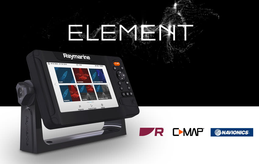
Smart 9" multifunction display with user-friendly interface and integrated GPS antenna. A classic keypad and the Raymarine LightHouse Sport interface make for intuitive operation. With built-in HyperVision sonar technology for outstanding image quality of the underwater world. The fast QuadCore processor is more than adequate for mapping and continuous 3D rendering. Supplied without transducer.

Raymarine Quantum Radar

Raymarine QUANTUM is the next generation of marine radar antennas with CHIRP technology. The QUANTUM provides razor-sharp images over both short and long distances.
NMEA2000 support

With the NMEA2000 (Micro-C) interface you can clearly display AIS, tank, engine, compass and wind data. This allows you to view incoming AIS targets directly on nautical charts and keep an eye on the surrounding shipping traffic. With the help of the data bar you can monitor your current tank levels for instance.
HyperVision 1.2 MHz Sonar Technology
HyperVision sonar technology uses top frequencies of up to 1.2 megahertz and CHIRP technology. This allows for a much higher image resolution compared to other systems. The top frequency of 1.2 MHz can reach a range of up to 30 meters at a beam angle of 180°. Use it to bring DownVision, SideVision and RealVision 3D imaging to a new level and to see structures, underwater vegetation and fish in photo-like clarity.
With the standard 350 kHz CHIRP sonar, you can receive high-resolution images at a range of up to 183 meters (DownVision) and 91 meters (SideVision / RealVision 3D). In addition, the classic CHIRP sonar operates at 200 kHz down to a depth of 274 metres.
Raymarine LightHouse Sport
Intuitive and visually striking user interface. Thanks to pre-configured home screens, every user has the start screen needed for his or her needs immediately at hand. With the ergonomically positioned buttons, navigation through the menus and placing waypoints and routes is quick and easy even without a touchscreen. Through an NMEA2000 interface, the Element-HV can display a wide range of data from external devices such as AIS receivers or tank sensors.
Your own nautical charts with RealBathy
With the new RealBathy function you can create your own nautical charts. Simply activate the function and your Element multifunction display with sonar function will create the nautical chart of your area. You can determine the overlay and display safety depths. Insert a large enough memory card into your device to do so.

Technical Specifications
| Screen size | 9" |
| Touchscreen | Non-Touch |
| Screen resolution | 800 x 480 |
| Brightness | 1500 nits |
| Network and compatibility | |
| GPS | Integrated GPS / GNSS receiver: GPS / GLONASS |
| Sonar | CHIRP-Sonar, DownVision (Standard und Hyper), SideVision (Standard und Hyper), Realvision-3D (Standard und Hyper) |
| Sonar connection | 15-pin HyperVision ™ connector |
| Sonar Depth | CHIRP sonar = 274 m (900 feet) DownVision ™ Standard = 183m (600ft) | DownVision ™ Hyper = 30m (100ft) SideVision ™ Standard = 91 m (300 feet) | SideVision ™ Hyper = 30m (100ft) RealVision ™ 3D Standard = 91 m (300 feet) | RealVision ™ 3D Hyper = 30m (100ft) |
| Nautical charts specification | |
| Supported nautical charts | Raymarine LightHouse NC2, Navionics, C-MAP Essentials, C-MAP 4D MAX+ and all charts listed on the Raymarine Chart Store. |
| Waypoints routes | 10,000 waypoints / 200 waypoints groups / 150 routes with max 250 waypoints / 16 tracks - 10,000 track points per track |
| Other specifications | |
| Interfaces | NMEA2000-Limited (engine, tank sensor & compass data input, data output: GPS for radio), Wi-Fi, Bluetooth For NMEA2000 GPS and AIS data update free of charge to the current Element Lighthouse Version 3.9. More information can be found on the Raymarine support page. |
| Dimensions | 287 x 161 x 62 mm |
| Nominal voltage | 12 V DC (8 V - 16 V DC) |
| Power consumption (amps) | 20 W |
| Water rating | IPX6 and IPX7 |
| Operating temperature | -25 °C to + 55 °C |
| Included in delivery | Mounting bracket with mounting hardware, surface mounting kit with mounting hardware, sun cover, power / NMEA2000 1.5m cable, documentation package |
Depth / fishfinder views
Depending on which the transducer is connected, the chartplotter can display the following depth views. The pure depth display refers to transducer data received via NMEA0183 or NMEA2000 interface. Some functions can be retrofitted via external modules.
Pure depth representation |
Fish finder / CHIRP |
Down vision |
RealVision 3D |
Compatible with:


Chart module:
SD/Micro-SD |
Compactflash |
C-Card MAX orange |
C-Card NT+ black |
Compatible with the following charts:
| C-MAP 4D | C-MAP 4D Full | C-MAP 4D Continental | Navionics+ | Navionics Platinum+ |
Chart features:
| Chart system | Vector maps | Grid/paper charts | Easy/Autorouting | Tides | Satellite images | High-resolution depth lines |
| C-MAP 4D | ||||||
| C-MAP 4D Full | ||||||
| C-MAP 4D Continental | ||||||
| Navionics+ | ||||||
| Navionics Platinum+ |
Features
Discover the features that make this product stand out. From technical details to special functions – we’ve summarized all the key information for you.
Display size
9 Inch
Operating mode
Keys
No
Radar capable
Yes (only via WiFi)
Yes
Viewing angle
Downwards
Sidewards
Sonar view
Fish
Bottom structure
3D bottom structure

Delivery contents
- Mounting bracket with fixing components
- Surface-mount kit with fixing components
- Suncover
- Power / NMEA2000 1.5 m cable
- Documentation pack

Documents
PDF (2,01 MB)
PDF (6,18 MB)
PDF (2,28 MB)
PDF (2,38 MB)
PDF (1,91 MB)
PDF (6,22 MB)
PDF (1,91 MB)
PDF (1,89 MB)
PDF (1,91 MB)
PDF (6,23 MB)
PDF (1,90 MB)
PDF (6,21 MB)
PDF (1,90 MB)
PDF (6,21 MB)
PDF (1,89 MB)
Systems
Product safety


Images for this rating
Customers ask customers
No questions asked yet. Be the first to ask a question!
More "Customers ask customers" available in the following languages
Similar items
-24%

RAYMARINE
Element 7S / buttons / CHIRP Sonar Module / with Lighthouse Chart
€529.55
only
€399.95
> 37
-6%
LOWRANCE
Eagle 5 with SplitShot™ HD Transducer
€391.51
only
€369.95
1
-8%
LOWRANCE
Eagle 7 with SplitShot™ HD Transducer
€546.21
only
€499.95
Expected to be in stock within 4-6 days
-8%
LOWRANCE
Eagle 7 with TripleShot™ HD Transducer
€653.31
only
€599.95
Available on 15.06.2026
-6%
LOWRANCE
Eagle 9 with TripleShot™ HD Transducer
€831.81
only
€779.95
1
-16%
LOWRANCE
Eagle 9 with 50/200 kHz HDI Transducer
€772.31
only
€649.95
3
Last seen products
Spare Wrench for Filler Neck
only
€6.50
60
BAVARIA
Lock for Access Door DIN Left
only
€63.95
-13%
PFEIFFER
Deck Organiser / 1 Wheel
€70.00
only
€60.95
7
-6%
WHALE
Repair Kit for HENDERSON Mk 5 Pump
€67.10
only
€62.95
26
Air Pressure Gauge
only
€10.95
19
G-NAUTICS
Winch Cover / acrylic / navy blue
only
€41.95
10
-16%
GLOMEX
Antenna Wind Indicator
€53.79
only
€44.95
16
Assemble online

-6%
PHILIPPI
STV 103 Switchboard / configurable
€85.00
only
€79.95
14
E-mail Newsletter
Product news, offers & new guide videos. Stay up to date!
WhatsApp
New: Get news from SVB straight to your phone!