B&G VULCAN 7R / Touch
SVB item number: 81641
Manufacturer no.: 000-14082-001


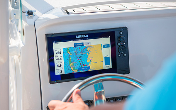
Packed with innovation and award-winning sailing features, the new B&G Vulcan multifunction display series is a must-have for every sailor. The Vulcan 7R features a 7" multi-touch display, built-in GPS and WiFi, excellent sonar technologies and radar compatibility. Transducer is not included. Product details
Recommended retail price:
€749.70
only
€649.95
-13%
You save: €99.75
5
| in stock
Having issues?
If you are not redirected to PayPal, it could be due to your browser settings. Please check and if necessary deactivate the setting "Hide IP address" in the settings -> Safari -> Hide IP address. Please also check your browser for updates.
If you are not redirected to PayPal, it could be due to your browser settings. Please check and if necessary deactivate the setting "Hide IP address" in the settings -> Safari -> Hide IP address. Please also check your browser for updates.
Are you already using this item?
Add to my boat now.
At a glance!
Product data
- SVB item number 81641
- EAN 9420024167373
- Manufacturer no. 000-14082-001
- Description B&G VULCAN 7R Multifunction Display / without transducer
- Series Vulcan
- Display size 7 Inch
- Resolution 800 x 480 px
- Viewing angle 80 °
- Screen brightness 1200 Nits
- Operating voltage 12 V
- Operating mode Touch screen
- NMEA2000 Yes
- NMEA0183 No
- WiFi Yes
- Bluetooth Yes
- Ethernet / Network No
- Radar capable Yes
- Tablet control Yes
- Sonar module Yes
- Sonar type CHIRP / Fishfinder, DownScan, SideScan, ForwardScan, Numerical depth
- Viewing angle Downwards, Sidewards, Forwards
- Compatible Navico transducers P79, P319, HDI, HST-WSBL, TotalScan, ForwardScan, Active Imaging, StructureScan HD
- Nautical chart support Yes
- Sea Charts C-MAP REVEAL, C-MAP DISCOVER, Navionics+, Navionics Platinum+, NV Charts
- Installation width 186 mm
- Installation height 126 mm
- With transducer No
- Sonar view Fish, Bottom structure
- IP protection class IPX7


Accessories


Product details
Packed with innovation and award-winning sailing features, the new B&G Vulcan multifunction display series is a must-have for every sailor. The Vulcan 7R features a 7" multi-touch display, built-in GPS and WiFi, excellent sonar technologies and radar compatibility. Transducer is not included.
With NMEA2000 connectivity, the Vulcan can be quickly and easily integrated into an onboard instrumentation system in order to take full advantage of the sailing features such as SailSteer and SailTime. In addition, the B&G Vulcan 7 is reasonably priced for a sailing chart plotter, ideal for offshore sailing and club racing.
User-friendly
The B&G Vulcan makes navigating and living on the water easier and safer! With familiar gestures, such as pinch-to-zoom and swipe, waypoints can be quickly and easily marked on the intuitive multi-touch display and routes can be planned with ease.
Special sailing functions for sailing or regattas
B&G stands for award-winning sailing features and ultimate navigation. All of your most important sailing data can be displayed together on one screen or superimposed on several maps. By simply linking all required sailing instruments, an intuitive graphical representation of wind data, wind direction, tides, speed, course and even jetties is possible. B&G SailingTime not only generates arrival times of beeline calculations, but also provides you with an accurate time based on the sailing course and the tides.
Easy integration
With industry-standard NMEA2000 connectivity, you can easily create a network of sailing instruments and sensors tailored to your needs. A special feature of the Vulcan 7R is the possibility to connect a radar via plug-and-play. Furthermore, your network can be expanded for example by autopilots, ForwardScan transducers or the SonicHub.
Secondary autopilot control panel
Use your Vulcan multifunction display as a secondary autopilot control panel for excellent navigation. The feature gives you easy access to Intelligent Sail Steering, manual and automatic control functions, and Smart Maneuver functions combined with intuitive menus.
Radar compatibility
The integrable B&G Broadband 3G or 4G radar provides excellent sailing support. Targets at a distance of up to 36 nautical miles (4G) can be recorded and evaluated with this feature.
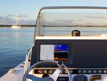
Monitor the underwater world with excellent sonar technology
Know what's inside the water ahead of you! With the help of high-quality sonar technology and an optional ForwardScan transducer, you can confidently explore even poorly documented or unknown waters.
Integrated WiFi
The built-in Wi-Fi feature allows you to connect the Vulcan to a compatible smartphone or tablet. This creates a cost-effective dual-band station that lets you control your multi-function display anywhere on board. You can also access and view selected online services such as PredictWind weather forecasts and routing via port or smartphone hotspots.
Product Overview
Technical specifications

With NMEA2000 connectivity, the Vulcan can be quickly and easily integrated into an onboard instrumentation system in order to take full advantage of the sailing features such as SailSteer and SailTime. In addition, the B&G Vulcan 7 is reasonably priced for a sailing chart plotter, ideal for offshore sailing and club racing.
User-friendly
The B&G Vulcan makes navigating and living on the water easier and safer! With familiar gestures, such as pinch-to-zoom and swipe, waypoints can be quickly and easily marked on the intuitive multi-touch display and routes can be planned with ease.
Special sailing functions for sailing or regattas
B&G stands for award-winning sailing features and ultimate navigation. All of your most important sailing data can be displayed together on one screen or superimposed on several maps. By simply linking all required sailing instruments, an intuitive graphical representation of wind data, wind direction, tides, speed, course and even jetties is possible. B&G SailingTime not only generates arrival times of beeline calculations, but also provides you with an accurate time based on the sailing course and the tides.
Easy integration
With industry-standard NMEA2000 connectivity, you can easily create a network of sailing instruments and sensors tailored to your needs. A special feature of the Vulcan 7R is the possibility to connect a radar via plug-and-play. Furthermore, your network can be expanded for example by autopilots, ForwardScan transducers or the SonicHub.
Secondary autopilot control panel
Use your Vulcan multifunction display as a secondary autopilot control panel for excellent navigation. The feature gives you easy access to Intelligent Sail Steering, manual and automatic control functions, and Smart Maneuver functions combined with intuitive menus.
Radar compatibility
The integrable B&G Broadband 3G or 4G radar provides excellent sailing support. Targets at a distance of up to 36 nautical miles (4G) can be recorded and evaluated with this feature.
Monitor the underwater world with excellent sonar technology
Know what's inside the water ahead of you! With the help of high-quality sonar technology and an optional ForwardScan transducer, you can confidently explore even poorly documented or unknown waters.
Integrated WiFi
The built-in Wi-Fi feature allows you to connect the Vulcan to a compatible smartphone or tablet. This creates a cost-effective dual-band station that lets you control your multi-function display anywhere on board. You can also access and view selected online services such as PredictWind weather forecasts and routing via port or smartphone hotspots.
Product Overview
- User-friendly multi-touch display
- Special sailing functions for sailing trips or regattas SailSteer, SailingTime, RacePanel, Resident
- Easy to integrate - Connect the Vulcan to an existing system and add basic sail components.
- Supports Broadband Radar ™ and ForwardScan ™
- Integrated WLAN
- Integrated GPS
- NMEA2000 connectivity
- Control your B&G autopilot
- Display of instrument data
Technical specifications
| Display: | 7" |
| Resolution: | 800 x 480 px |
| Dimensions: | 197 x 141 x 82.7 mm |
| Weight: | 1.32 kg |
| Waterproof: | IPX6 and IPX7 |
| Voltage: | 12 V DC (10 - 17 V DC) |
| Power consumption: | Average 12 W / maximum 20 W |
| GPS: | 10 Hz antenna integrated |
| WiFi: | Integrated |
| Bluetooth: | Integrated |
| Ethernet: | Yes |
| NMEA2000: | Yes |
| NMEA0183: | No |
| AIS: | Optional, via NMEA2000 |
| Radar: | Yes, compatible with Halo, Broadband and HD radars |
| Sonar compatibility: | CHIRP, DownScan and ForwardScan |
| Card Compatibility: | Navionics +, Navionics Platinum +, C-MAP MAX-N, C-MAP MAX-N +, C-MAP Genesis and NV Digital Cards |
| Languages: | English (US + UK), German, Spanish, French, Italian, Dutch, Danish, Swedish, Norwegian, Greek, Portuguese |
Charts module:
SD / Micro SD |
CompactFlash |
C-Card MAX orange |
C-Card NT + black |
Compatible with the following nautical charts:
| C-MAP MAX-N | C-MAP MAX-N + | C-MAP MAX-N + Continental | Navionics + | Navionics Platinum + |
Nautical charts features:
| Chart system | Vector charts | Grid/paper charts | easy-/AutoRouting | Tides | Satellite images | High-resolution depth lines |
| C-MAP MAX-N | ||||||
| C-MAP MAX-N + | ||||||
| C-MAP MAX-N + Continental | ||||||
| Navionics + | ||||||
| Navionics Platinum + |
Features
Discover the features that make this product stand out. From technical details to special functions – we’ve summarized all the key information for you.
Display size
7 Inch
Operating mode
Touch screen
No
Radar capable
Yes
Tablet control
Yes
Viewing angle
Downwards
Sidewards
Forwards
Delivery contents
- Display
- Installation kit for panel mounting
- Seal
- Mounting screws
- Sun protection
- Cables
- Fuse holder and fuse
- Protective caps
- Documentation package
- Installation instructions
- Quick guide
- Mounting template
- Bracket installation kit
- U-bolt
- Mounting screws
- Bracket knobs
Documents
PDF (4,84 MB)
PDF (2,65 MB)
PDF (133,65 KB)
PDF (1 018,40 KB)
PDF (4,82 MB)
PDF (21,19 MB)
PDF (2,50 MB)
PDF (5,36 MB)
PDF (21,03 MB)
PDF (2,50 MB)
PDF (4,73 MB)
PDF (20,89 MB)
PDF (2,48 MB)
PDF (4,72 MB)
PDF (21,26 MB)
PDF (2,49 MB)
PDF (2,53 MB)
Product safety


by
Horst S.
 7/13/2024
Verified purchase
7/13/2024
Verified purchase
by
Ove O.
5/14/2024
Verified purchase
by
Yann G.
 12/14/2023
Verified purchase
12/14/2023
Verified purchase
by
Peter C.
 3/29/2023
Verified purchase
3/29/2023
Verified purchase
Customers ask customers
Technical question
Kestutis Č.
| May 14, 2024

Hi, I hope this email finds you well. I have a 9m sail boat and I would like to change equipment for the navigation. My preference is chartplotter B&G Zeus 3 7 with world basemap, Wind transmitter NAVICO NMEA 2000 608, forwaedScan transducer NAVICO, CAMINO-108S AIS Transponder, Compression Radar HALO20 Pulse. I am not sure how all this equipment could be connected and how to ensure that it works properly. What else is needed to make sure that I could sail safely and most importantly securely? Kind regards, Kestutis
Answer from SVB customer service
Karen S.
| May 17, 2024
Dear Kestutis, for this kind of inquiries please contact us at [email protected].
Technical question
Jacques Christian H.
| Feb 25, 2024
EXCEPT THE SIZE, are the « Vulcan 7R » functions and capabilities same as the « Vulcan 9 FS » ? If not, what are the advantages of the 9 ? Thanks, Chris
Answer from SVB customer service
Karen S.
| Apr 16, 2024
Dear Jacques, apart from the size, the two plotters can do the same thing.
Technical question
Vadim P.
| Jan 20, 2024
Very disappointed with the touchpad on this chartplotter. At times it gets stuck and can only respond to the fifth or sixth press. Initially I thought maybe the protective film was interfering with the correct operation, but it wasn’t there. Should it be like this? It’s just in a cozy room on a table, but what about offshore... I tried to calibrate the screen but it didn’t help.
Answer from SVB customer service
Karen S.
| Apr 16, 2024
Dear Vadim, thanks for reaching out. Satisfying our customers is very important to us and I’m sorry we couldn't meet your requirements. Please share your experience at [email protected] so that we can help you solve this problem.
Technical question
Vaidotas M.
| May 3, 2023
good afternoon, Does B&G vulcan 7r have nautiocal charts of any region or it's fully empty?
Answer from SVB customer service
Andreas M.
| May 5, 2023
Hello Vaidotas, a rough world map is integrated in all devices. The details such as harbor plans, depth contours, buoys, etc. are only available via an optional sea chart. For this we have a link above under the pictures "Find a compatible chart".
Technical question
Janez K.
| Jan 25, 2021
Hello, I am buying B&G Vulkan 7R, and I would allso like to use the fishfinder function as well. Which fishfinder transducer can I use with it? I would like to use on my sport sailboat that I occasionally use for fishing, so transducer should be pretty hydrodynamic al that it does not make any additional drag in the water (inhull or thruhull). Thanks for advice in advance. Regards, Janez.
Answer from SVB customer service
Cory V.
| Oct 10, 2022
Dear customer, please email [email protected] for assistance.
Customers also bought

Leak and Emergency Plug Set
only
€8.50
> 100
-17%
YACHTCARE
LEAK HERO Sealant / 625 ml
€44.30
only
€36.95
(€59.12 / L)
66
NMEA2000
T-Piece / Micro-C
only
€21.95
Available on 10.08.2026
NMEA2000
Network Cable / Micro-C
from
€31.95
6 variants
NMEA2000
4-way Splitter / Micro-C
only
€71.95
67
NMEA2000
Starter Kit / Micro-C
only
€133.95
> 100
Similar items
-30%
B&G
VULCAN 9FS / Touch
€1,071.00
only
€749.95
> 15
-24%
B&G
VULCAN 9 FS + HALO20+ Doppler Radar Bundle
€4,082.30
only
€3,099.95
> 4
-24%
B&G
VULCAN 9 FS + TrueHeading AIS Transponder Bundle
€2,246.96
only
€1,699.95
4
-31%
B&G
VULCAN 9 FS + ForwardScan Bundle
€2,031.87
only
€1,399.95
2
-15%
B&G
ZEUS SR-10 Multifunctional Display
€3,276.05
only
€2,799.95
-14%
B&G
ZEUS SR-12 Multifunctional Display
€4,853.99
only
€4,179.95
-12%
B&G
ZEUS SR-16 Multifunctional Display
€7,038.83
only
€6,199.95
-12%
B&G
ZEUS S 7 / Touch
€1,248.31
only
€1,099.95
8
-12%
B&G
ZEUS S 9 / Touch
€1,724.31
only
€1,519.95
5
-12%
B&G
ZEUS S 12 / Touch
€3,271.31
only
€2,879.95
> 5
Last seen products
E-mail Newsletter
Product news, offers & new guide videos. Stay up to date!
WhatsApp
New: Get news from SVB straight to your phone!