GARMIN GPSMAP 723 Multifunction Display
SVB item number: 93859
Manufacturer no.: 010-02365-00


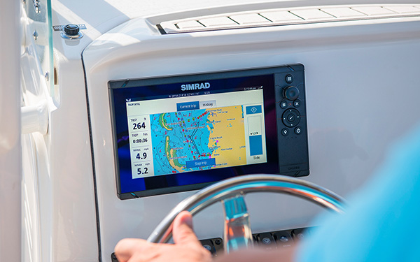
The new GPSMAP series from Garmin has a significantly higher resolution and even faster processing power. The 7" multifunction display features an optimised map display, excellent user interface and can be easily integrated into the Garmin marine system. Product details
Recommended retail price:
€1,049.00
only
€949.95
-9%
You save: €99.05
2
| in stock
Having issues?
If you are not redirected to PayPal, it could be due to your browser settings. Please check and if necessary deactivate the setting "Hide IP address" in the settings -> Safari -> Hide IP address. Please also check your browser for updates.
If you are not redirected to PayPal, it could be due to your browser settings. Please check and if necessary deactivate the setting "Hide IP address" in the settings -> Safari -> Hide IP address. Please also check your browser for updates.
Are you already using this item?
Add to my boat now.
Available variants

At a glance!
Product data
- SVB item number 93859
- EAN 753759250430
- Manufacturer no. 010-02365-00
- Description GARMIN - GPSMAP 723
- Series GPSMAP
- Display size 7 Inch
- Resolution 1024 x 600 px
- Operating voltage 12 V, 24 V
- Operating mode Touch screen
- NMEA2000 Yes
- NMEA0183 Yes
- WiFi Yes
- Bluetooth No
- Ethernet / Network Yes
- Radar capable Yes
- Tablet control Yes
- Sonar module Optional
- Sonar type RealVü 3D, FrontVü, LiveScope, LiveVü Down, LiveVü Forward, Numerical depth
- Viewing angle Downwards, Forwards
- Compatible Garmin transducers PS30, PS31, PS51, LVS32
- Nautical chart support Yes
- Sea Charts BlueChart g3, BlueChart g3 Vision, Garmin Navionics+, Garmin Navionics Vision+
- Installation width 181 mm
- Installation height 119 mm
- With transducer No
- Sonar view Bottom structure, 3D bottom structure
- IP protection class IPX7


Product details
Faster, sharper, smarter!
The new GPSMAP series from Garmin has a significantly higher resolution and even faster processing power. The 7" multifunction display features an optimised map display, excellent user interface and can be easily integrated into the Garmin marine system. In addition, its bright screen is even easier to read in sunlight.
Garmin Sailassist
See laylines, start line guidance, an enhanced wind rose, heading and course-over-ground lines,true and apparent wind data, and controls for tide, current and time, wind angle, drift, current, wind speed and more.
Optional bluechart sea charts
The Bluechart g3 and Bluechart g3 Vision maps combine the best data from Garmin, Navionics, Auto Guidance technology and other premium navigation features.
Garmin Marine Network
Easily share information with other Garmin devices on your boat, such as maps, user data, radar data and IP camera data.
NMEA2000 and NMEA0183 compatibility
Connect your chartplotter directly to autopilots, digital switching, weather data, the FUSION Link audio system, media, VHF, AIS and more.
ActiveCaptain app
Connect your device to Wi-Fi and link it to the free mobile ActiveCaptain app. This gives you access to the OneChart feature, Smart Notifications, software updates, Garmin Helm, Garmin Quickdraw community, and more.
Integrated ANT technology
Easily connect your devices such as quatix marine clocks, gWind Wireless 2 transducers, GNX Wind marine instruments and radio remote controls to the GPSMAP Plus.
JI939 connectivity
Easily integrate data from different engines (including Yamaha engines).
ONEHELM function
This function displays all third-party options on one page, e.g. EmpireBus Digital Switching.
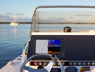
PANOPTIX support
Connect your chartplotter to the easy-to-read PANOPTIX or PANOPTIX LIVESCOPE sonar (transducers sold separately) and get a real-time, all-round view under and alongside your boat.
Technical Data
General
Maps and memory
Outdoor recreational features
Further functions
Sonar functions
Connections

The new GPSMAP series from Garmin has a significantly higher resolution and even faster processing power. The 7" multifunction display features an optimised map display, excellent user interface and can be easily integrated into the Garmin marine system. In addition, its bright screen is even easier to read in sunlight.
Garmin Sailassist
See laylines, start line guidance, an enhanced wind rose, heading and course-over-ground lines,true and apparent wind data, and controls for tide, current and time, wind angle, drift, current, wind speed and more.
Optional bluechart sea charts
The Bluechart g3 and Bluechart g3 Vision maps combine the best data from Garmin, Navionics, Auto Guidance technology and other premium navigation features.
Garmin Marine Network
Easily share information with other Garmin devices on your boat, such as maps, user data, radar data and IP camera data.
NMEA2000 and NMEA0183 compatibility
Connect your chartplotter directly to autopilots, digital switching, weather data, the FUSION Link audio system, media, VHF, AIS and more.
ActiveCaptain app
Connect your device to Wi-Fi and link it to the free mobile ActiveCaptain app. This gives you access to the OneChart feature, Smart Notifications, software updates, Garmin Helm, Garmin Quickdraw community, and more.
Integrated ANT technology
Easily connect your devices such as quatix marine clocks, gWind Wireless 2 transducers, GNX Wind marine instruments and radio remote controls to the GPSMAP Plus.
JI939 connectivity
Easily integrate data from different engines (including Yamaha engines).
ONEHELM function
This function displays all third-party options on one page, e.g. EmpireBus Digital Switching.
PANOPTIX support
Connect your chartplotter to the easy-to-read PANOPTIX or PANOPTIX LIVESCOPE sonar (transducers sold separately) and get a real-time, all-round view under and alongside your boat.
Technical Data
General
| Dimensions | 192 x 140 x 74 mm |
| Display size, W x H | 7" diagonal (154 x 91 mm) |
| Display resolution, W x H | 1024 x 600 pixels |
| Display type | WSVGA-display |
| Weight: | 1.3 kg |
| Water rating | IPX7 |
| Polarized support | Yes |
| JI939 connectivity | Yes |
| current consumption (watts) | Max. power consumption at 10 V DC: 17.6 W Typical current consumption at 12 V DC: 1.1 A Max. current consumption at 12 V DC: 1.5 A |
| Antenna | Internal or external via NMEA2000 |
| Mounting options | Installation with bracket or flush |
| Receiver | Highly sensitive with 10 Hz |
| Garmin Marine Network ports | 1 |
| Included in delivery | GPSMAP 723, microSD-card, power cord, NMEA2000 T, NMEA2000 drop cable (2 metre), bail mount kit with knobs, flush mount kit with gasket, protective cover, trim piece snap covers, documentation |
Maps and memory
| Preinstalled chart | Worldwide base map |
| Accepted data cards | 2 microSD memory cards; maximum 32 GB |
| waypoints | 5000 waypoints |
| routes | 100 routes |
| Track log | 50,000 points, 50 saved tracks |
Outdoor recreational features
| Tide tables with optional Bluechart map | Yes |
Further functions
| Compatible with GARMIN radars | Yes |
| Compatible with GARMIN sonars | Optional (with external black box, sold separately) |
| Compatible with GARMIN Smartmode (customisable screen presets) | Yes |
| AIS support | Yes |
| DSC support | Yes |
| Fusion Link compatibility | Yes |
| ActiveCaptain compatibility | Yes |
| Supports GSD™ black box sonar | Yes |
| Supports GCV™ black box sonar | Yes |
| Compatible with GRID (Garmin remote input device) | Yes |
| Compatible with radio remote control | Yes |
| Sailing features | Yes |
Sonar functions
| Chirp sonar technology | Optional (with external black box) |
| Clearvü | Optional (with external black box, sold separately) |
| Sidevü | Optional (with external black box, sold separately) |
Connections
| NMEA2000® compatible | Yes |
| NMEA0183 inputs | 1x |
| NMEA0183 outputs | 1x |
| Video input ports | 1x BNC |
| Video output ports | No |
| Wireless connectivity | Yes |
Features
Discover the features that make this product stand out. From technical details to special functions – we’ve summarized all the key information for you.
Display size
7 Inch
Operating mode
Touch screen
Yes
Radar capable
Yes
Tablet control
Optional
Viewing angle
Downwards
Forwards
Delivery contents
1x GPSMAP 723 chart plotter
1x microSD™ card, pre-installed
1x power cable
1x NMEA 2000® T
1x NMEA 2000 power cable (2 metres)
1x Mounting bracket set with fastening knobs
1x Installation kit for flush mounting with seal
1x Protective cover
1x Click rims for mounting
1x Documentation
1x microSD™ card, pre-installed
1x power cable
1x NMEA 2000® T
1x NMEA 2000 power cable (2 metres)
1x Mounting bracket set with fastening knobs
1x Installation kit for flush mounting with seal
1x Protective cover
1x Click rims for mounting
1x Documentation
Documents
Product safety

by
Holker S.
 10/8/2025
Verified purchase
Variant:
93860
in use on a Dehler Yachtbau GmbH - Sprinta 70
10/8/2025
Verified purchase
Variant:
93860
in use on a Dehler Yachtbau GmbH - Sprinta 70
Images for this rating

Customers ask customers
Technical question
Yorgos E.
| Nov 23, 2022

Can this display Target Speed for sailing after uploading a Polar Table file? Also is this possible to send Target Speed to BnG Triton3 screen via NMEA 2000 network?
Answer from SVB customer service
Andreas M.
| Dec 2, 2022
Hello Yorgos, Yes the device can display Target Speed after upload a Polar table file. Send this data´s by NMEA2000 is actually not possible.
Comparison


Availability / Price
Item no.
93859
93860
Customer ratings
Description
GARMIN - GPSMAP 723
GARMIN - GPSMAP 723xsv
NMEA0183
NMEA2000
Ethernet / Network
WiFi
Bluetooth
Display size
7 Inch
7 Inch
Sonar module
Optional
Operating mode
Touch screen
Touch screen
Series
GPSMAP
GPSMAP
Installation height
119 mm
119 mm
Installation width
181 mm
181 mm
Nautical chart support
Sonar type
RealVü 3D, FrontVü, LiveScope, LiveVü Down, LiveVü Forward, Numerical depth
CHIRP / Fishfinder, ClearVü, SideVü, RealVü 3D, FrontVü, LiveScope, LiveVü Down, LiveVü Forward, Numerical depth
With transducer
Operating voltage
12 V, 24 V
12 V, 24 V
Viewing angle
Downwards, Forwards
Downwards, Sidewards, Forwards
Radar capable
Sea Charts
BlueChart g3, BlueChart g3 Vision, Garmin Navionics+, Garmin Navionics Vision+
BlueChart g3, BlueChart g3 Vision, Garmin Navionics+, Garmin Navionics Vision+
Tablet control
Sonar view
Bottom structure, 3D bottom structure
Fish, Bottom structure, 3D bottom structure
Resolution
1024 x 600 px
1024 x 600 px
IP protection class
IPX7
IPX7
Compatible Garmin transducers
PS30, PS31, PS51, LVS32
P319, GT8, GT21, GT34, GT52, GT54, GT56, PS30, PS31, PS51, LVS32, LVS34, LVS62
Customers also bought
Similar items
-7%

GARMIN
GPSMAP 723xsv with Sonar Module
€1,259.00
only
€1,169.95
2
-6%
GARMIN
GPSMAP 923
€1,579.00
only
€1,479.95
2
-6%
GARMIN
GPSMAP 923xsv with Sonar Module
€1,789.00
only
€1,679.95
1
-7%
GARMIN
GPSMAP 1223
€3,048.99
only
€2,849.95
Expected to be in stock within 1-2 weeks
-5%
GARMIN
GPSMAP 1223xsv with Sonar Module
€3,259.01
only
€3,079.95
Expected to be in stock within 4-6 days
GARMIN
GPSMAP 8410
only
€2,799.95
> 4
-8%
GARMIN
GPSMAP 8410xsv
€3,149.00
only
€2,899.95
Expected to be in stock within 1-2 weeks
-7%
GARMIN
GPSMAP 8412
€4,099.00
only
€3,799.95
> 7
GARMIN
GPSMAP 8416
only
€6,199.95
-9%
GARMIN
GPSMAP 8416xsv
€6,829.01
only
€6,229.95
E-mail Newsletter
Product news, offers & new guide videos. Stay up to date!
WhatsApp
New: Get news from SVB straight to your phone!